
దస్త్రం:Mercator north pole 1595.jpg
ఈ మునుజూపు పరిమాణం: 635 × 600 పిక్సెళ్ళు. ఇతర రిజల్యూషన్లు: 254 × 240 పిక్సెళ్ళు | 508 × 480 పిక్సెళ్ళు | 813 × 768 పిక్సెళ్ళు | 1,084 × 1,024 పిక్సెళ్ళు | 1,700 × 1,606 పిక్సెళ్ళు.
అసలు దస్త్రం (1,700 × 1,606 పిక్సెళ్ళు, ఫైలు పరిమాణం: 1.13 MB, MIME రకం: image/jpeg)
సారాంశం
| వివరణ |
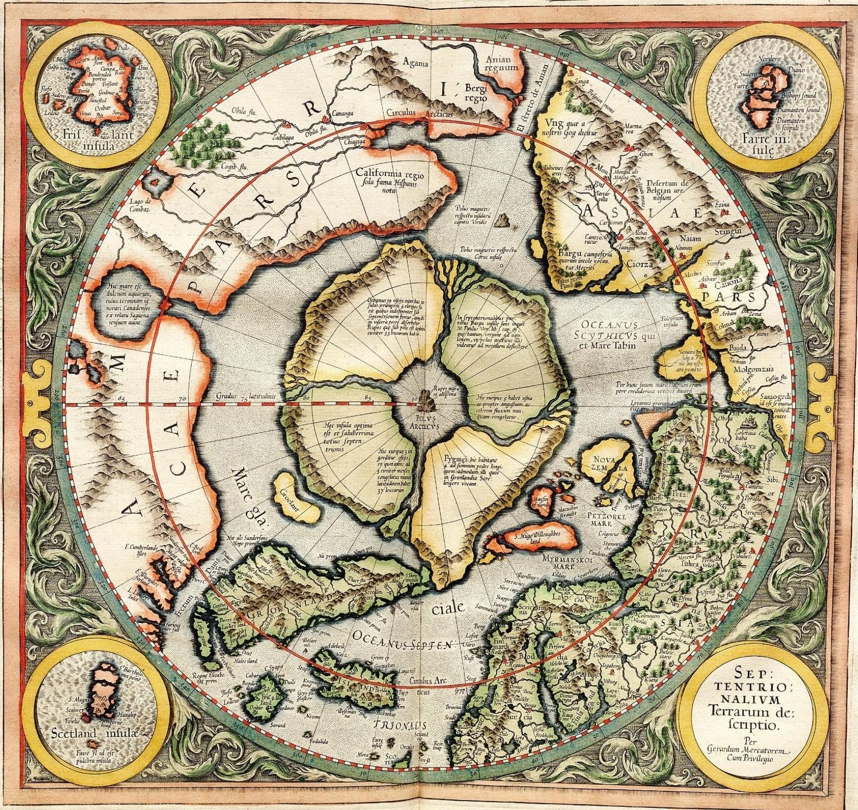
Mercator's 1595 map of the Arctic. Mercator, Gerhard, 1512-1594. "Septentrionalium Terrarum descriptio" [1595]. First state, from his posthumously published atlas, Atlantis pars altera. |
||||||||||||||||||||||||||
| తేదీ | |||||||||||||||||||||||||||
| మూలం | http://libweb5.princeton.edu/visual_materials/maps/websites/northwest-passage/mercator.htm | ||||||||||||||||||||||||||
| కర్త |
|
||||||||||||||||||||||||||
| అనుమతి (ఈ దస్త్రాన్ని పునర్వినియోగించుకోవడం) |
|
||||||||||||||||||||||||||

లైసెన్సింగ్
|
This work is in the public domain in its country of origin and other countries and areas where the copyright term is the author's life plus 100 years or fewer. | |
| This file has been identified as being free of known restrictions under copyright law, including all related and neighboring rights. | |
_-_Geographicus_-_NorthPole-mercator-1606.jpg)
]
దస్త్రపు చరిత్ర
తేదీ/సమయం ను నొక్కి ఆ సమయాన ఫైలు ఎలా ఉండేదో చూడవచ్చు.
| తేదీ/సమయం | నఖచిత్రం | కొలతలు | వాడుకరి | వ్యాఖ్య | |
|---|---|---|---|---|---|
| ప్రస్తుత | 11:32, 14 మార్చి 2008 | | 1,700 × 1,606 (1.13 MB) | Pallidio~commonswiki | {{Information |Description= |Source= |Date= |Author= |Permission= |other_versions= }} Maps made in the 16th century | Gerardus Mercator | Maps by Gerardus Mercator | 1595 | Old maps of the world | |
దస్త్రపు వాడుక
కింది పేజీ ఈ ఫైలును వాడుతున్నాయి:
సార్వత్రిక ఫైలు వాడుక
ఈ దస్త్రాన్ని ఈ క్రింది ఇతర వికీలు ఉపయోగిస్తున్నాయి:
- ba.wikipedia.org లో వాడుక
- be-tarask.wikipedia.org లో వాడుక
- be.wikipedia.org లో వాడుక
- de.wikipedia.org లో వాడుక
- en.wikipedia.org లో వాడుక
- eo.wikipedia.org లో వాడుక
- es.wikipedia.org లో వాడుక
- fr.wikipedia.org లో వాడుక
- hy.wikipedia.org లో వాడుక
- it.wikipedia.org లో వాడుక
- ja.wikipedia.org లో వాడుక
- ka.wikipedia.org లో వాడుక
- la.wikipedia.org లో వాడుక
- nl.wikipedia.org లో వాడుక
- pa.wikipedia.org లో వాడుక
- pl.wikipedia.org లో వాడుక
- ru.wikipedia.org లో వాడుక
- sv.wikipedia.org లో వాడుక
- te.wikipedia.org లో వాడుక
- tt.wikipedia.org లో వాడుక
- zh.wikipedia.org లో వాడుక